10 Best Gps Chartplotters 2026 in the United States


Related Products
Up to 38% off


Our technology thoroughly searches through the online shopping world, reviewing hundreds of sites. We then process and analyze this information, updating in real-time to bring you the latest top-rated products. This way, you always get the best and most current options available.
Our Top Picks
Winner
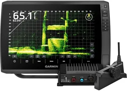
Garmin ECHOMAP Ultra 2 12-inch Chartplotter with LiveScope Plus Bundle, GPS, Chirp Sonar, Navionics+ Charts
The Garmin ECHOMAP Ultra 2 features a large 12-inch screen with a sharp 1280 x 800 resolution, making maps and sonar images easy to see even in bright light. It combines touchscreen with button controls, catering to users who prefer physical buttons for reliability in rough conditions. The chartplotter supports Navionics+ charts preloaded for U.S. waters, ensuring detailed and updated navigation maps. Its GPS receiver is advanced, using multiple satellite systems (GPS, GLONASS, GALILEO, BEIDOU) with a fast 10 Hz refresh rate for very accurate and responsive positioning.
Connectivity options are robust, including dual microSD slots for extra maps or data, two network ports, and NMEA 2000 compatibility, allowing seamless connection with other marine electronics. The included LiveScope Plus sonar system delivers live scanning sonar views with high detail, which greatly benefits serious anglers and boaters wanting to track fish and underwater structures in real time.
The unit weighs about 14 pounds, which might be a consideration for smaller boats or for portability. While the touchscreen controls are responsive, some users may find the hybrid control method requires some adjustment if they prefer a single control approach. This product suits boaters and anglers seeking a premium, feature-rich chartplotter with excellent sonar and navigation capabilities, especially those who value a large, clear screen and strong connectivity for system integration.
Garmin ECHOMAP UHD2 73sv with GT54 Transducer, 7” Touchscreen Chartplotter, Garmin Navionics+ U.S. Inland
The Garmin ECHOMAP UHD2 73sv is a solid choice for anyone needing a reliable GPS-chartplotter, especially for inland and freshwater fishing. Its 7-inch touchscreen is bright and easy to read even in sunlight, which helps when you're outdoors. The included GT54 transducer supports several sonar types, including traditional and scanning sonars, giving good underwater visibility up to 1,000 feet depth. Built-in Garmin Navionics+ maps cover over 18,000 lakes in the U.S. with detailed contours, making it very useful for anglers and boaters exploring inland waters.
Connectivity is a strong point here, with Wi-Fi allowing you to share routes and sonar data wirelessly with other compatible devices. It also integrates seamlessly with Garmin’s Force trolling motor for advanced control right from the chartplotter. The touchscreen interface is intuitive for most users, though those preferring physical buttons might miss that option. While the screen resolution is standard WVGA and not the highest possible, it balances clarity and power use well. The product is reasonably lightweight and offers flexible mounting options for different boat dashboards.
One downside is that this unit is designed primarily for inland and freshwater use, so it may not have all the marine features preferred by ocean anglers. Additionally, it comes at a mid to higher price point, reflecting its advanced features. This unit is a user-friendly and reliable device packed with useful fish-finding and navigation tools, ideal for freshwater boating enthusiasts looking for an integrated solution.
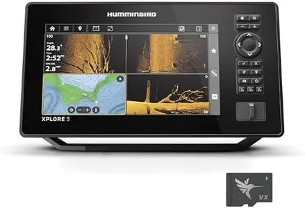
Humminbird XPLORE 9 GPS Fish Finder with Transducer, MEGA Side Imaging+ & HD Touchscreen
Most important from
57 reviews
The Humminbird XPLORE 9 is a solid choice for anglers looking for a reliable GPS chartplotter and fish finder combo. It features a sharp 9-inch HD touchscreen with a 1280 x 720 resolution, making it easy to see detailed sonar images and maps even in bright conditions. The MEGA Side Imaging+ sonar technology stands out by providing clear views up to 200 feet on each side, which helps spot fish and underwater structures effectively. It also includes MEGA Down Imaging+ and Dual Spectrum CHIRP sonar, offering detailed fish detection and depth readings.
Its built-in GPS comes preloaded with a detailed Basemap covering over 10,000 lakes, plus it supports popular chart cards like LakeMaster, CoastMaster VX, and Navionics, which is great for users needing reliable navigation and chart compatibility across US and Canada waters. The AutoChart Live feature is a bonus, allowing users to create custom depth maps in real time while boating. Connectivity options are well-thought-out, with high-speed Ethernet, Bluetooth, and NMEA 2000 network compatibility. This enables smooth integration with other marine electronics like Minn Kota trolling motors and Cannon downriggers, which can make fishing more efficient.
The device offers both a touchscreen and traditional keypad controls, catering to different user preferences and situations where touchscreen use might be tricky (like wet conditions). The unit weighs around 9 pounds, which is on the heavier side for portability. The Humminbird XPLORE 9 is designed for anglers who want advanced sonar imaging, versatile GPS charts, and strong connectivity options in a durable, easy-to-use package.